


Highways Department of the Government of Tamil Nadu has formulated and approved Information and Communication Technology Strategy (ICTS) in 2008, setting with the following challenges
- To achieve the vision of Highways.
- Develop hardware and network infrastructure.
- Manage & deploy GIS based Road Information System across the state network.
- Deploy Financial and Accounts, HR, Project management, Document Management applications.
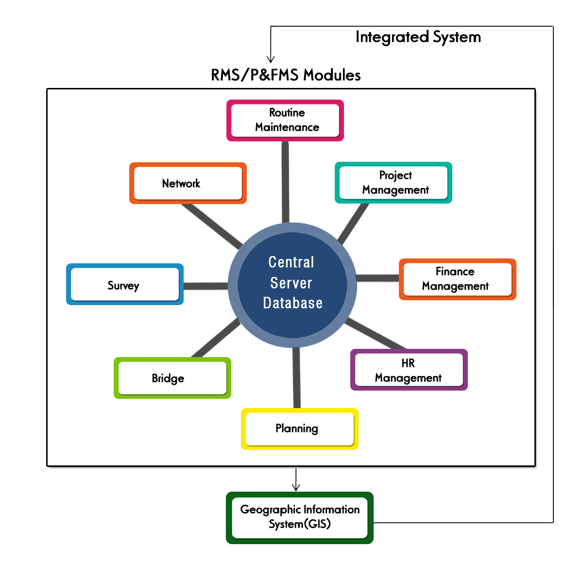
For effectively managing the maintenance of road network and related infrastructure in Tamil Nadu, the Hon’ble Chief Minister had inaugurated e-Pathai (electronic Project, administration, traffic, highway assets & information Management System) system comprising of following software developed under ICTS.
- e-Pathai - ROAD MAINTENANCE MANAGEMENT SYSTEM RMMS
- e-Pathai - GEOGRAPHIC INFORMATION SYSTEM GIS
- e-Pathai - INTEGRATED PROJECT, HUMAN RESOURCE AND FINANCE MANAGEMENT SYSTEM P&FMS(LIVE), P&FMS(Training)
- ROAD ACCIDENT DATA MANAGEMENT SYSTEM RADMS
Road Maintenance Management System (RMMS)RMMS is a computerised system developed by Highways Department to manage the Maintenance of network of roads more judiciously and efficiently. The road network is subjected to damage caused by wear and tear and sub-standard conditions may develop. The aim of Road Management System is to ensure free, safe, comfortable flow of traffic and preserve the road network in a fairly good condition. Since, a number of variables influence the road deterioration, managing the asset by manual method is a complex task. Therefore use of computerised system to undertake the maintenance activities more efficiently is necessitated. RMMS application is web enabled and hosted system. The design of a Road Management System is based on the concepts of “Systems engineering” and “Management techniques”. RMMS is “a system which employs a set of formalised procedures used by managers to evaluate alternative strategies in a systematic and co-ordinated manner with the objective of providing, maintaining and managing a road system at minimum cost and maximum efficiency.” RMMS framework comprises two major components, an information system, which collects, organises and manages data and information; and decision-support systems, which comprise application modules to process data and provide the information on which decisions can be based and ultimately implemented. Field data required for RMMS are collected using ROMDAS (Road Measurement and Data Acquisition System) equipments procured by Highways Department and fed in RMMS. Data available in RMMS can be analysed with HDM4 software and the economic feasibility of any road project can be obtained for prioritization. Click here to get into RMMS |
Geographical Information System (GIS)Geographical Information System (GIS) developed under ICTS comprises of two components viz., Road Information System and Bridge Information System. A GIS integrates hardware, software, and data for capturing, managing, analyzing, and displaying all forms of geographically referenced information. GIS allows us to view, understand, question, interpret, and visualize data in many ways that reveal relationships, patterns, and trends. The system is a mix of digital base maps for Tamil Nadu consisting of several layers (spatial data) compiled from different sources such as Survey of India (SOI), National Bureau of Soil Survey and Land Use Planning (NBSS&LUP), Wikimapia, High Resolution Satellite Imagery etc. and attribute data (non-spatial data) on roads, bridges etc. from RMMS database besides other attribute data of interest such as demographic details from Census of India, average annual rainfall data from India Meteorological Department. The Web GIS based Road & Bridge Information System developed for TNHD under e-Pathai GIS is a web based system for
Currently data in RMMS has been integrated into the Web GIS for query, reporting and thematic visualization. The Web GIS system is dynamically linked to RMMS database, which means that the latest data on roads and bridges as and when updated in RMMS is available for query, reporting and analysis in the Web GIS. Interfacing of data from ADCE (Advanced Data Collection Equipment) and financial data from P&FMS (Projects Human Resources & Finance Management System) for roads & bridges is also part of this Web GIS implementation. Click here to get into GIS |
Integrated Project, Human Resource & Finance Management System (P&FMS)To automate the existing manual procedures in Highways Department, it was decided to develop and implement the software, Project & Finance Management System. The modules defined in the software are Project Management system, Finance Management System and Employee Record system. All the data related to important projects are digitized and made available in the system in electronic format. Also establishment related particulars will be stored in the data base. This will ensure efficient and transparent functioning of the department. This system has been developed for the Departments internal use to improve the overall functioning. |
Road Accident Data Management System (RADMS)A web enabled GIS based Road Accident Data Management System (RADMS) for Tamil Nadu has been developed by World Bank assisted Tamil Nadu Road Sector project wing of the Highways Department in coordination with Police, Transport and Highways Departments. The RADMS application facilitates.
The software is used by Highways Department, Police Department and Transport Department. RADMS is an accident database management system that ensures visibility and manageability of road safety programs. Using the solution, the police can record a host of information regarding road accidents. The software is GIS (Geographic Information System) enabled, allowing users to pinpoint the exact geographic location of the accident by directly plotting on a map or using GPS handsets to obtain coordinates. This integrated information is then made available to generate different kinds of reports required by various stakeholders which can help them scientifically plan and implement appropriate intervention measures to reduce road accidents/enhance road safety. The cumbersome paper-based reporting processes which may trigger lack of clarity in First Information Reports, lack of availability of data and a heavy backlog would all be eliminated with this powerful application. The Government entrusted the responsibility of RADMS in respect of data collection, data recording and reporting with the Additional Director General of Police, State Traffic Planning Cell (STPC). With this reliable data base, different kinds of analysis by various user departments concerned can be done and interventions can be implemented to improve the Road Safety Scenario in Tamil Nadu. Click here to get into RADMS |